Electronic Navigation Console ENC3-PRO - full set dedicated for Seacraft Ghost scooters
Military-grade diver navigation console with dead-reckoning and GPS re-calibration via external GPS/buoy (0.1 m, 3 m, 10 m options). Supports up to 29 waypoints, 50 route storage, Bluetooth/USB data exchange, and is rated to 300 m depth.
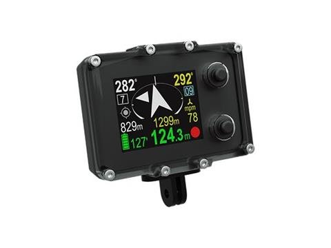
ENC3-PRO Electronic Navigation Console
The ENC3-PRO is a civil and scientific version of the Seacraft ENC3-MIL military navigation system. It provides underwater dead-reckoning navigation with optional GPS recalibration via an external miniature GPS receiver and buoy, and can be used mounted on a diver propulsion vehicle (DPV), with a surveyor tool, or as a standalone console.
Key features
- Dead-reckoning underwater navigation with GPS re-calibration (FIX) when surface position is available
- Supports an external miniature GPS module with 0.1 m, 3 m, or 10 m cable and buoy options
- Up to 29 programmed waypoints and storage for 50 routes
- Route planning and track export (CSV, KML for Google Earth, GIS-ready)
- Multiple sensors: 3D magnetometer, 3D gyroscope, 3D accelerometer, pressure and temperature sensors
- Data exchange via Bluetooth 4.2 and/or USB
How it works
Underwater the ENC3-PRO uses dead-reckoning to calculate the diver's position. When a reliable GPS signal is received (via the connected GPS module or buoy at the surface), the system recalibrates to the GPS FIX position and continues navigation from that point. Divers can navigate to any pre-programmed waypoint at any time, or follow an ordered route.
Route planning and logging
Waypoints and routes are programmed using the provided PC freeware. Points may be set on a map or entered as coordinates or azimuth/distance and can include short text descriptions visible on the console underwater. Logged tracks and GPS positions are stored in the ENC3-PRO memory and can be exported for post-dive analysis.
Specifications
- Depth of start/stop of immersion time counting: optional 0.5 m, 1 m or 1.6 m (compatible with EN 13319)
- Depth measurement accuracy: ±0.3 m (temperature range 0–30°C)
- External log accuracy: <2%* (depends on calibration and absence of external interference)
- Compass accuracy: <3°* (depends on calibration and absence of interference)
- Maximum operating altitude above water level: up to 5000 m
- Internal storage: 50 routes, 29 programmed waypoints
- Satellite positioning: GPS, BeiDou, GLONASS
- Included sensors: 3D magnetometer, 3D gyroscope, 3D accelerometer, pressure sensor, temperature sensor
- Data exchange: Bluetooth 4.2 and/or USB
- Battery: built-in Li-ion 3.7 V; charge time <2 h. Device can be charged from any 5 V DC source (charging current up to 1 A)
- Dimensions: width 30.6 mm, length 95 mm, height 71 mm
- Weight: 290 g
- Maximum depth rating: 300 m (tested to 350 m)
- Displacement: -90 g
- Operating temperature: +10 to +45°C; storage temperature: -20 to +45°C; temperature while charging: +10 to +40°C
*Measurement accuracy depends on quality of calibration and absence of external interference.
Included with ENC3-PRO
- E_1130 ENC3-PRO console
- E1060 speed sensor type D
- F1079 mounting bracket Ø208 mm
- E1140 GPS set with buoy type B and 10 m connecting cable
- E1126 GPS cable winding holders (2 pcs.) attachable to transport brackets
- E1124 GPS float holder attachable to transport bracket