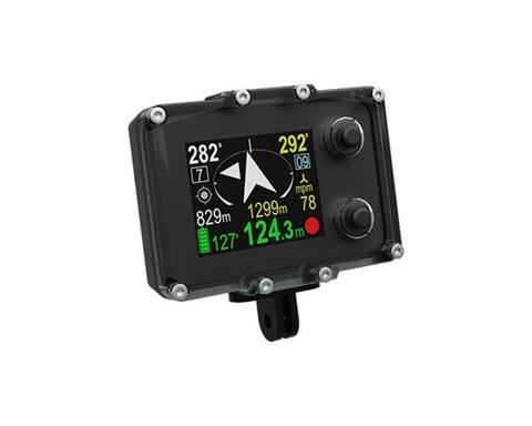
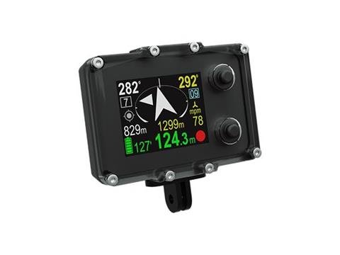
Electronic Navigation Console ENC3‐PRO
Military-grade electronic navigation console for divers with multi-waypoint navigation, underwater dead-reckoning, and optional external GPS recalibration via buoy or short-mounted module. Supports PC route planning, track export, Bluetooth/USB data exchange, and can be mounted on scooters or used standalone.
Seacraft ENC3-PRO Electronic Navigation Console
The ENC3-PRO is a civil and scientific version of Seacraft's military-grade underwater navigation console. It provides multi-waypoint navigation, underwater dead-reckoning position calculation, and optional GPS recalibration via an external miniature GPS receiver mounted on a buoy or connected directly by cable. The unit can be used mounted on a diver propulsion vehicle (DPV), with a surveyor tool, or as a standalone console.
How it works
- Underwater navigation uses dead-reckoning to calculate position when GPS is unavailable.
- When a GPS fix is acquired (via a surface float or short-mounted module), the ENC3-PRO recalibrates the current position and continues navigation from that fixed point.
- Divers can select and navigate to any pre-programmed waypoint at any time during the dive.
Modularity and GPS options
- Supports a miniature GPS (Type B) that can be connected directly with a 0.1 m cable or with 3 m or 10 m cables and a buoyancy float for surface reception without surfacing the diver.
- Cable lengths are quick-change and require no tools; longer cables can be wound on dedicated holders attached to a DPV.
- Can be installed on scooters or used independently depending on mission needs.
Route planning and data
- Free PC software for planning routes and programming up to 29 waypoints; points may be entered as GPS coordinates or azimuth/distance and can include short text descriptions.
- Logged tracks can be reviewed after dives and exported in multiple formats (e.g., KML for Google Earth, GIS formats, or CSV).
- All obtained GPS positions are stored in device memory for survey and archaeological applications.
Key specifications
- Navigation memory: 50 routes, 29 programmed waypoints
- Included sensors: 3D magnetometer, 3D gyroscope, 3D accelerometer, pressure sensor, temperature sensor
- Satellite positioning: GPS, BeiDou, GLONASS
- Data exchange: Bluetooth 4.2 and/or USB
- Depth of start/stop immersion time counting: optional 0.5, 1.0 or 1.6 m (EN 13319 compatible)
- Depth measurement accuracy: 0.3 m across the full depth range (temperature range 0–30 °C)
- External log accuracy: <2%*; compass accuracy: <3°*
- Battery: built-in Li-ion 3.7 V; full charge <2 h. Device can be charged from any 5 V DC source; charging current up to 1 A.
- Dimensions: Width 30.6 mm, Length 95 mm, Height 71 mm; Weight: 290 g
- Maximum operational depth: 300 m (tested to 350 m)
- Displacement: -90 g
- Operating temperature: +10 … +45 °C; Storage: -20 … +45 °C; Charging temperature: +10 … +40 °C
* Measurement accuracy depends on calibration quality and absence of external interference.
Package contents
- E_1130 Electronic Navigation Console ENC3-PRO (console)
- E1040 soft transport case
- E1085 charging cable
- E1083 spare seals set (4 pcs)
- E1127 KIPP screws (2 pcs)